
Earthquake Risk In Bali
What are the chances of there being an earthquake in Bali?
What is the risk of there being an earthquake in Bali, how large could it be and how much damage can we expect? Here we look at past earthquakes that have occurred and the location of tectonic plate action that causes earthquakes in Indonesia to assess whether there is likely to be an earthquake and how big it could be. We also look at Tsunamis caused by earthquakes, we list the amount of damage and deaths to be expected from different magnitude of earthquakes.
See also:
- Design of buildings to resist earthquakes
- Why houses fall down in earthquakes
- Dangerous developments in architectural design
- Checking your building for earthquake damage
Indonesia is a Very Active Area
The 2009 earthquake in West Sumatra reminds us once again that we live in a very disturbed region and a high risk area. This was the fifth major disaster caused by earth movement in recent years starting with the Tsunami in 2004, Yogyakarta in 2006, Padang in 2009, Palu in 2018 and Lombok in 2019. Once again we find that the thing most likely to kill us is the building we work or live in. Let us start by understanding what causes earthquakes and in particular that most important question - how safe are we in Bali?
First there are many basic facts it is useful to know:
What Causes an Earthquake?
Earthquakes are caused by earth movement along fault lines. A fault is a crack in the earth along which movement occurs. The ground on one side may move in any direction relative to the other, up, down, sideways or even towards or away from the other. The faces of these cracks are understandably rough and, as one side slides against the other it tends to stick, stress builds up until the resistance can be overcome, suddenly it releases and moves. The sudden movement causes an earthquake.
The Earth's Crust and Tectonic Plates
Geological faults occur all over the earth and vary from small to extremely, unbelievably gihuge. There is, however, a pattern of major fault lines over the earth's surface. Only fairly recently (in the 1960s) did we come to understand that the earth's crust is rather like a broken egg shell with pieces that float around. These pieces are known as tectonic plates, they are 5 to 70 kms thick being made up of the crust and upper mantle of the earth which float on the mantle beneath.
In some places these plates move past each other, in other places they move apart. In yet other places the plates are pushed together forcing up mountains or with the edge of one plate being pushed under the other causing a trench on one side and a mountain range on the other. These plates are always in motion typically moving 0.6 cm to 8.5 cms per year.
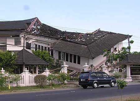
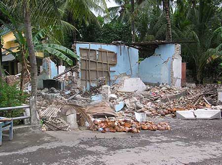 Many houses were totally destroyed
Indonesia, including Bali, is in a very active, high risk area.
Now we come to the relevant part - what is the risk of a major earthquake Bali. Australia, New Guinea and much of the Indian Ocean are on what is called the Australia Plate while Malaysia, Southern Philippines, much of Thailand, Cambodia, Vietnam and all of Indonesia (apart from West Irian) are on a smaller plate known as the Sunda Plate. The Australia Plate is moving northwards at the amazing speed of 6 cms a year and is pushing underneath the Sunda Plate. The line where these plates meet runs just South of Timor, South of Sumba then along to the West about 250 kilometres South of Bali and Java until somewhere to the West of Yogyakarta it turns North West and runs about 220 kilometres off the West coast of Sumatra and up through the Andaman Islands. To the South of this line is a deep trench in the sea bed known as the Sunda Trench.
This is where the action is - Earthquakes, Volcanoes, Tsunamis, we are living on one of the most unstable areas on the planet.
Two points to note: As an earthquake occurs and relieves the stress in on place this will increase the stress further along the fault line leading to further quakes until stress is relieved and everything settles down. Bali is further East on the same plate boundary as Aceh, Padang and Yogya.
If we have a long period between earthquakes in any particular place this is known as a seismic gap, in this case we have to be very careful because we can expect that a lot of stress has built up and we can expect a big one.
Professor Kerry Sieh from Singapore's Nanyang University reports that we have had 30 or more earthquakes magnitude 6 or greater in the Sumatra region in the past 10 years. He believes we are entering a cycle of activity that comes around every 200 years or so. He also suggests we haven't had “the big one” yet.
How we measure the size of an earthquake
The severity of earthquakes is measured on the Moment Magnitude Scale (MMS) which replaced the earlier Richter scale (the values are effectively the same) which gives a measure from 1 to 10 of the shaking amplitude.
It is important to note that the scale is logarithmic (remember those log tables? – probably not!) which means that each single point higher represents a 10 times greater amount of shake!
The energy release of an earthquake which is related to how much damage it can do is even greater with each point higher in the scale relating to 31.6 times more destructive power. The following table gives you an idea of what this means.
Moment Magnitude Scale or MMS
| MMS | Descripn | TNT Equivalent |
Possible Results | World Frequency |
|---|---|---|---|---|
| <2 | Micro | 1 metric ton | Not felt | 8,000 per day |
| 2 to 2.9 | Minor | 5.6 metric tons | Not felt but recorded | 1,000 per day |
| 3 to 3.9 | Minor | 178 metric tons | Often felt but rarely causes damage | 49,000 per year |
| 4 to 4.9 | Light | 5.6 kilotons | Noticeable shaking of indoor items | 6,200 per year |
| 5 to 5.9 | Moderate | 178 kilotons | Can cause minor damage to weak buildings | 800 per year |
| 6 to 6.9 | Strong | 5.6 megatons | Destructive in areas up to 160 miles across | 120 per year |
| 7 to 7.9 | Major | 178 megatons | Can cause serious damage over large areas | 18 per year |
| 8 to 8.9 | Great | 5.6 gigatons | Serious damage areas hundreds of miles across | 1 per year |
| 9.to 9.9 | Great | 178 gigatons | Devastating in areas thousands of miles across | 1 per 20 years |
| >10 | Epic | 1 teraton | Never recorded | Unknown |
Siesmic Hazard - the measurement of ground movement
Another measure is “Seismic Hazard” which is expressed by the term “Peak Ground Acceleration” or PGA. What on earth does that mean? Well PGA is a measure of how hard the ground shakes and is measured in percentage of g force (g is acceleration due to gravity 1g = 9.81 metres per sec per sec.). PGA is used by engineers to calculate earthquake induced forces on buildings.
In terms of seismic hazard the most dangerous area in Indonesia is down the full length of Western Sumatra. This area has a PGA of 40 to 60%g (there is only one grade higher in the scale - over 60%g). Sumatra is particularly dangerous because, in addition to the tectonic plate boundary offshore, there is a second fault line which runs down the full length of the spine of high ground along the West coast.
Denpasar and Southern Bali is in the next category down at 30 to 40%g along with much of the western coastal strip of Sumatra and the southern coast of Java. The rest of Bali is 25 to 30%g along with Mataram, Bandung and Jakarta. Yogyakarta comes in at 20 to 25%g while the northern areas of Java are a tame (well for Indonesia anyway) 15 to 20%g.
Notable earthquakes in Indonesia
A selection of notable earthquakes in terms of destruction or closeness to Bali:
| Place | Date | Magnitude | Depth | Deaths |
|---|---|---|---|---|
| 60 km WNW of Padang, Sumatra | 30/09/09 | 7.6 | 81 | ? |
| 70 km SE of Denpasar, Bali | 19/09/09 | 5.7 | 74 | |
| 100 km SSW of Bandung, Java | 02/09/09 | 7 | 46 | 72 |
| 215 km NE of Denpasar, Bali | 07/02/08 | 5.7 | 304 | |
| 110 km SW of Denpasar, Bali | 31/12/07 | 4.7 | 30 | |
| 191 ENE of Denpasar, Bali | 04/10/07 | 5.6 | 13 | |
| 50 km NE of Padang, Sumatra | 06/03/07 | 6.4 | 19 | 70 |
| 326 km SE of Denpasar, Bali | 02/08/06 | 5.8 | 30 | |
| 260 km S of Bandung | 17/07/06 | 7.7 | 34 | 730 |
| 20 km SSE Jogjakarta | 27/05/06 | 6.3 | 10 | 5,749 |
| 245 km SW of Medan, Sumatra | 28/03/05 | 8.6 | 30 | 1,313 |
| 250 km SSE Banda Aceh, Sumatra | 26/12/04 | 9.1 | 30 | 227,898 |
| Irian Jaya | 17/02/96 | 8.2 | 166 | |
| Flores | 12/12/92 | 7.8 | 2,519 | |
| Seririt, Bali | 14/07/76 | 6.5 | 559 | |
| Papua | 25/06/76 | 7.1 | 5,000 | |
| Buleleng, Bali | 29/03/62 | 6.1 | ||
| Tulungagung | 05/07/59 | 5.4 | ||
| Bali | 21/01/17 | 6.9 | 1,500 |
In recent years there have been many large earthquakes in the region not included on this list. These were mostly at greater depths and so caused lower levels of death or destruction. Shallow earthquakes cause more damage.
The statistic of the number of deaths belies the full magnitude of the devastation caused. For each death there are many more people injured and many buildings destroyed. In the 2006 Yogyakarta earthquake 5,749 people were killed, a further 38,568 people were injured, 127,000 houses were totally destroyed and a further 451,000 were damaged.
Ground movements cause Tsunamis
The largest death tolls often result from Tsunamis. A Tsunami is a large wave cause by ground movement under the sea. If ground movement is horizontal along a fault line it is unlikely that tsunamis will occur but if movement is vertical then water is displaced and tsunamis are more likely to result. The devastating Aceh earthquake of 2004 produced a major vertical shift creating a huge wave (15 metres high) that wiped huge land areas clean and killed nearly a quarter of a million people.
To the south of Bali the Australia Plate is sliding under the Sunda Plate creating vertical movement and so we should expect that we are susceptible to Tsunamis.
Damage and Deaths in the Yogyakarta
In the Yogya earthquake of 2006 people died mostly from houses and walls falling down on them. Buildings were very poorly built with little reinforcement. There were very few landslides and most concrete buildings withstood the quake. The terrible thing about this earthquake was the length of time, 58 seconds, which resulted in oscillations being set up which literally shook buildings to pieces.
The latest Padang earthquake (death toll not yet known) the source of risk appears to have been different. It is noticeable that many solid, well built buildings collapsed and major landslides buried villages and hamlets.
As a final note a seismic hazard assessment for Denpasar carried out by the Institute of Technology, Bandung is as follows:
A PGA of 0.25 to 0.4%g with expected effects of ground shaking, liquifaction (shaking turns the ground into a thick liquid), ground failure (cracks and collapse) and Tsunami.
Our assessment of the risk in Bali
From all this we can conclude that:
- Bali is in a high risk earthquake area.
- We can expect large earthquakes to occur from time to time.
- Earthquakes are totally unpredictable and can occur at any time.
- We have not had a large one for quite a while.
- We can expect Tsunamis to result from earthquakes in Bali.
If you would like further information on earthquakes you can start at the US Geological Survey website at: https://earthquake.usgs.gov
See also:
- Design of buildings to resist earthquakes
- Why houses fall down in earthquakes
- Dangerous developments in architectural design
- Checking your building for earthquake damage
Phil Wilson
Copyright © Phil Wilson October 2009
This article, or any part of it, cannot be copied or reproduced without permission from the copyright owner.